Thinking that this was going to be your typical "wait for the heat of the day to build up and produce storms in the afternoon" kind of day, we all got dressed and went to church. Before we left, I checked the morning sounding and was a bit discouraged.
A sounding is a way to get a look at the cross section of air from the ground all the way up into the troposphere. Around the country at various National Weather Services offices a weather balloon is launched twice a day - once in the morning and once in the evening. Attached to the weather balloon is an instrument called a radiosonde. This device measures temperature, moisture (dew point), wind speed and direction. When plotted on a graph called a Skew-T Log P Diagram, you get the above diagram. The red line on the right is the temperature plot and the green line is the dew point. See how at just above the 1 km level the temperature goes UP and the moisture goes DOWN? This is known as a CAP, or temperature inversion. This prevents parcels of air from rising and, thus, growing into thunderstorms. Given enough energy, the cap can be broken, but many times a strong cap (like the one above) means that storms have little chance of forming.
Back at church - about 9:15, just as the kids were getting settled into their Sunday school classes, it began to get quite dark outside. Not wanting to miss anything, I repeatedly went outside to stare into the sky. I'm sure I looked quite foolish.
Five minutes later a line of storms that I later found out was caused by gravity wave and a surface trough that preceded a dry line swept through the area. They fired up quite quickly and produced some pea to dime sized hail!
After 5 minutes of rain, the skies cleared up and it was blue sky as far as the eye could see! Was this it? Was this the "Slight Risk" that the SPC has been warning us for days in advance? Needless to say, the elation of being in a good hail storm quickly turned to frustration.
That afternoon, as the kids played outside, the mundaneness of Sunday afternoons was in full effect. I had just begun to plan that week's grocery list when the kiddos mentioned that they heard thunder. I brushed it off saying, "Yes, it's probably far away..." and went back to my grocery list. Luckily, I had my radar program up and running and much to my surprise, I see some activity building up to our southeast!
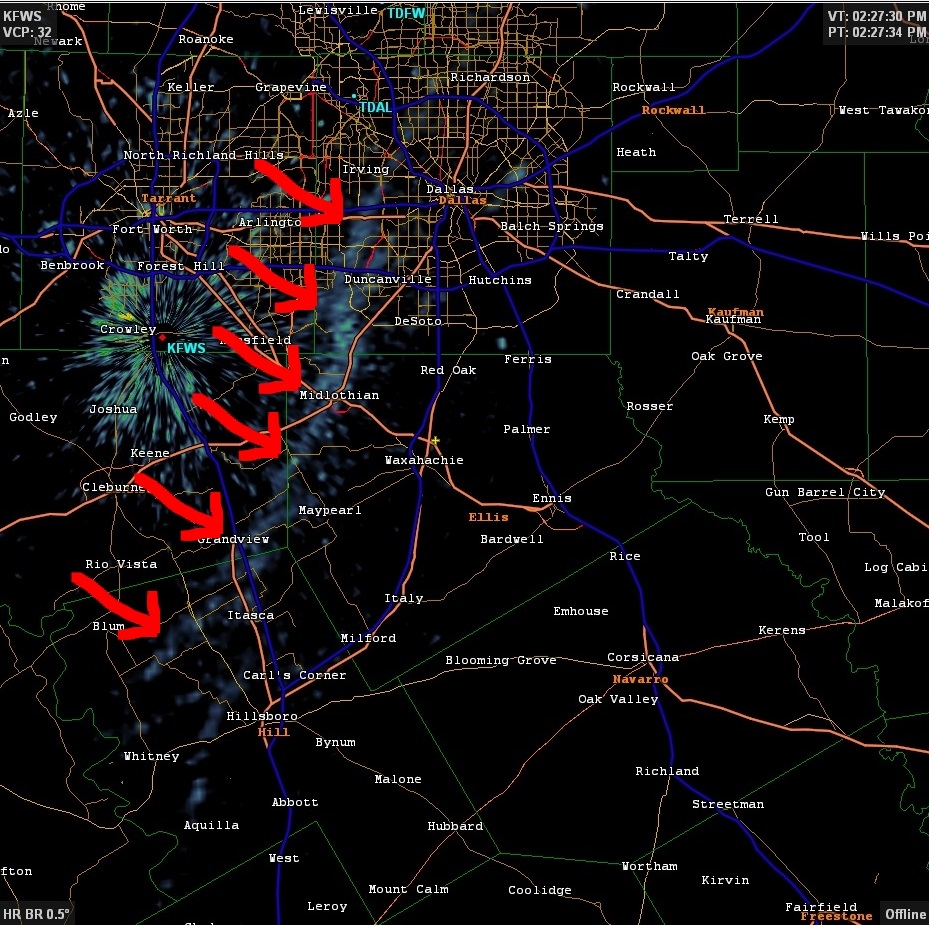
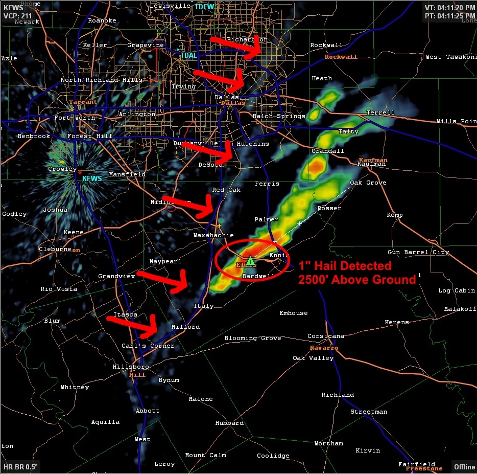
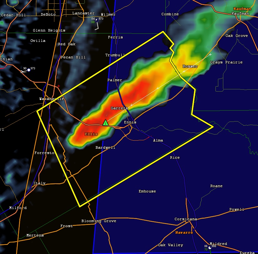
Although I didn't realize it at the time, a cold front had been approaching from the west. A "front" is a boundary between two different air masses. The air in my area was warm and moist, but the air behind the front was cool and dry. When cool air pushes under warmer air, this can cause lift in the atmosphere and thus contribute to the development of thunderstorms. To illustrate this, look at the following 3 radar snapshots:
The radar that the National Weather Service uses is sensitive enough to show fronts, given the right conditions. The "stuff" that the radar is seeing may be dust or insects that are being blown by the front itself. The front on this day was clearly visible - denoted by the red arrows. This snapshot was from 2:27PM.
An hour later, at 3:27 PM the front was progressing eastward and small thunderstorms began to show up on radar. In other words, the cold air behind the front was pushing underneath the warmer and moister air ahead. This pushed UP the warmer air into the atmosphere where it was less buoyant that air around it. As a result, it continued to rise and give way to storms.
By 4:11 PM, the front was directly over Waxahachie and there was some major development happening to our southeast. Radar was already indicating that there was 1" hail around 2500 feet above the ground. It was around this time that the kids noted they heard thunder. I finished up what I was working on, stepped outside and saw this awesome sight. (full pic here)
I could tell that this wasn't your ordinary thunderstorm! The size and shape was screaming SUPERCELL! At the time this picture was taken (about 4:26 PM), the National Weather Service had already issued a severe thunderstorm warning. The blue shaded area to the east indicates that a severe thunderstorm watch had already been issued.
I jokingly said to my wife that we should go chase the storm since it was so close. Much to my surprise, she said, "Sure, let's go!" So my wife, 4 out of my 5 kids and I all jumped into the car and headed south on US 287 to chase!
The structure of this storm was crazy! It's really something to see that big in person. It is almost surreal to watch it transform right in front of your eyes. These next 3 shots are over the course of just 4 minutes.
I knew from my storm spotting classes and all the research I've done on storms and storm chasing that the best (and usually the safest) place to be is on the rear-right flank of the storm. This position typically allows for best viewing. Keeping this in mind, we kept the storm at our left and attempted to stay south and east of it.
We got to Ennis, TX and headed south on I-45 for a mile or to and ended up taking FM85 East. This is a pretty windy road but generally heads east. We had been on this very same road a few weeks ago to check out the bluebonnets, so I was fairly familiar with it. The problem was that although we were headed generally east - the storm was tracking northeast. This meant that as time went on, the storm was getting further and further away. I didn't have my computer's radar program with me at the time - which was making me a bit uneasy. I only had my phone's radar app and Google maps - both very good tools, but a bit hard to use when you're trying to intercept a storm! The radar program indicated that the there was some broad circulation near the back of the storm. This area is where tornados usually form. I wasn't expecting a tornado by any means, but this was certainly the area that I wanted to focus on.
With the storm getting further and further away, I knew that we needed to head north. About 7 miles west of the town of Seven Points, we turned north onto FM2613. It soon became clear that this was a great choice! As we continued north, we could begin to see the backside of the storm. The base of the storm was still pretty high up (this is one indication of a lower tornado threat). However, saw what I thought was a pretty-well defined wall cloud. A wall-cloud is a lowering in a base of a thunderstorm and is the area where a tornado would form. This section of the storm has no rain associated with it (an area technically called a rain-free base) and is the part of the storm that contains the largest updrafts. Although there was broader circulation with the whole storm, I didn't see that this wall cloud was rotating. We found a place to stop and I snapped this:
By this time, my adrenaline was pretty high. After all this was really only my second storm chase and being out in the field is entirely different than all of the textbook diagrams and charts that I had been pouring over in the months past. For a moment, I hesitated. What this really a wall cloud? Maybe it was something else altogether. After going back and forth a few times in my head, I made the decision to call in a report to the local National Weather Service. To this day, I'm not sure they received the report.
We followed the storm into the town of Kemp where we ended up stopping to get gas. Realizing that it was about dinner time and we had the kiddos with us, we got snacks for them too. They were overjoyed at this! As we were filling up, I snapped this from my radar app.
With snacks in had and gas in the car, we continued to chase the storm NE. We made it as far as Canton before we decided to call it quits. Although we would have liked to continue, we had already missed a deadline to pick up our oldest daughter and needed to get back home for that. The storm already had gotten quite a bit ahead of us, so I was looking like a lost cause. But all wasn't lost! After all only being out for the second time, we did end up seeing a wall cloud and calling in to make a report. I'd call that success! But as we were driving home, I couldn't help but go over the chase in my head. Did I make the right call by calling in the report? Was it really a wall cloud that we saw? I tried not to let all these nagging questions get in the way of the smile across my face.
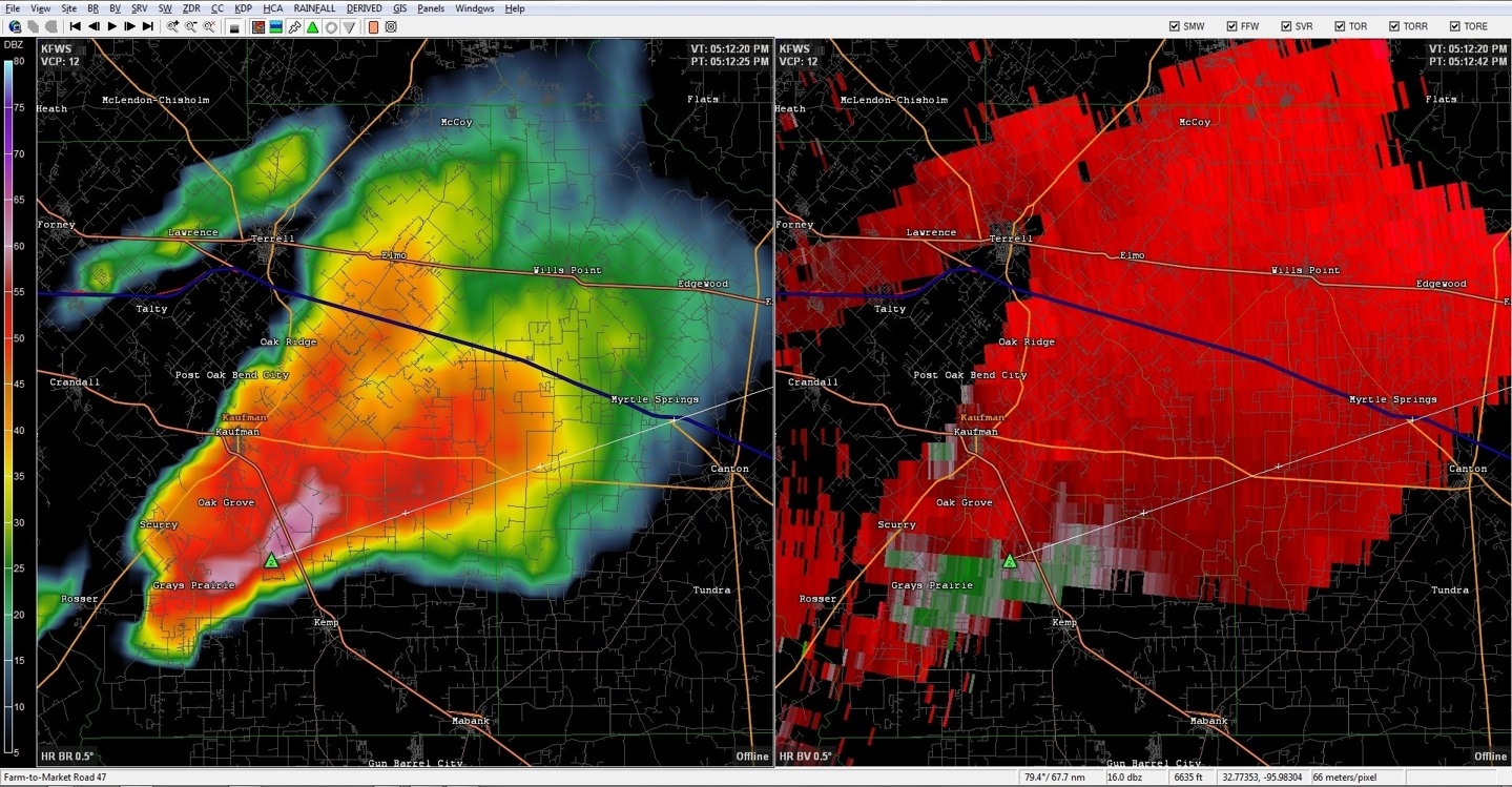
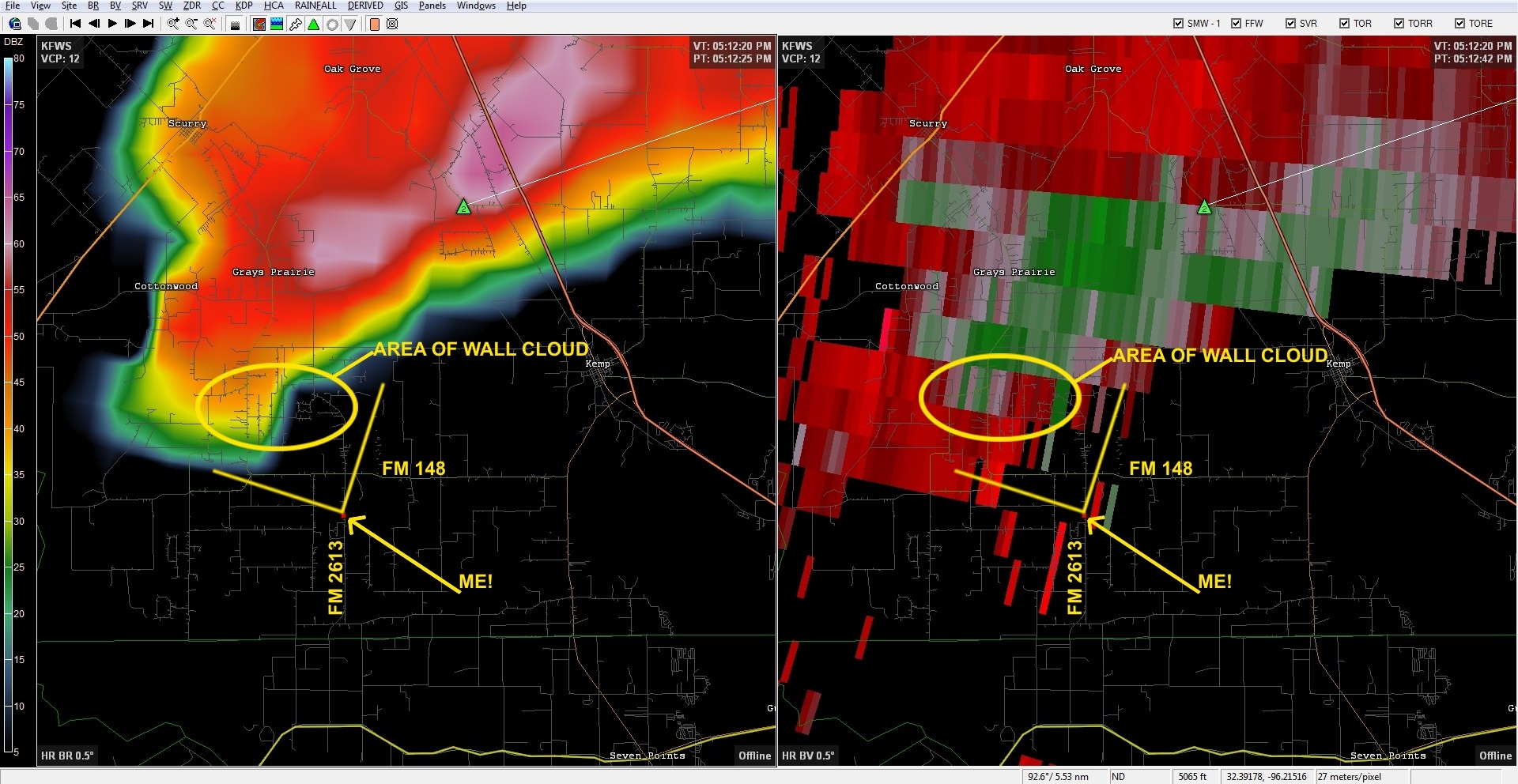
Fast forward half a week and I decided to try to pull up some historical Level III radar data to see if I could analyze what it was we saw. Data from all the WSR-88D Nexrad Radars are archived and can be pulled up at any time. I found the time frame I needed and proceeded to import them into my desktop radar program. What I found out was nothing less than spectacular.
The time stamp on this frame of radar data is 5:12 PM - which is EXACTLY the same time that I had photographed what I thought was the wall cloud. Looking that this view proves a few things to me. 1) This storm was indeed a supercell. The shape of the reflectivity data (the view on the left) is nearly a classic-textbook shape. 2) This storm did have some broad rotation as indicated by the red/green colors in the pane on the right (Green colors show winds that are blowing toward the radar and red colors indicate winds that are blowing away from the radar). I zoomed in further, added some annotations, and everything began to fall into place. Here is the final product. A larger view can be seen here.
This picture shows my position relative to the storm. The yellow lines are my approximate field of vision and line up exactly where a wall cloud should be. This, without a doubt, proves that what I did see was, in fact, a wall cloud! Not too bad for my second-ever chase.
In the future, I may not be able to construct each chase in this level of detail, but I hope to be able to see (and document) some pretty wild weather.
-Andrew






No comments:
Post a Comment