On Friday, September 26, 2014, the drive home from work was pretty commonplace and uneventful. A few miles away from home, I noticed some interesting clouds to my south (yes, I spend a lot of time looking UP at the sky when I probably should be looking at the road!). Be that as it may, I finished my drive home and when I got into the driveway, I immediately shut off the car and snapped this picture:

I was pretty excited as these looked very much like the jellyfish clouds I had read about a few weeks prior. However, I didn't want to make too much of it, so I decided to check the sounding data for that day to confirm my suspicions. I've referred quite a bit to soundings in my previous posts, and it's a topic about which I solely need to devote a topic, but to briefly recap a sounding can be thought of as a cross section of the atmosphere from the ground level all the way up through the troposphere (the area of the atmosphere where all the weather takes place). Soundings come out at 8AM and 8AM during daylight saving time (7AM and 7PM otherwise). Data is generated by an instrument called a radiosonde which is attached to a weather balloon. This instrument and balloon are released from National Weather Service offices all around the country and help meteorologists get an idea of the makeup of the atmosphere above. They measure temperature, dew point, wind speed and direction. It was about 6 PM when I arrived home, so the only thing I had at my disposal were the morning sounding. Here's what it showed:

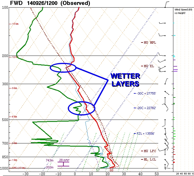
This graphic contains a TON of information, but the focus for the rest of this article will be on the upper left corner. This plot - showing the red and green lines - is a graphical depiction of both the temperature (red line) and dew point (green line) starting at the surface (the bottom of the graphic) rising up to some 15-17 km (49,000 - 55,000 ft.) in the air.
The first thing you notice is that the red and green lines are fairly close together near the bottom. The lowest layer - often referred to as the PBL, or Planetary Boundary Layer, shows that due to the proximity of the lines, there is a fair amount of humidity in the air. Above the PBL, the green line veers sharply to the left. This indicates that the next layer up is very dry. Above that, it gets more humid, then dry again, then humid, then dry. Who knew so much was going on above our heads!! Here's a better explanation:

In these dry layers, no clouds can form as there is simply not enough moisture. However, when the lines get close, this indicates that there is sufficient humidity for clouds to form. In fact, depending on where the layers are, you get different types of clouds!

Remember above when I said that jellyfish (altocumulus) clouds form in a moist layer which is sandwiched between two drier layers? Well, this is exactly what we had in the atmosphere that day. In other words, this did confirm to me that, yes, what I had captured earlier were the elusive jellyfish clouds! From the morning sounding it looks like they were forming above the 6 km (~19,000 ft) mark. The precipitation which was dropping from them fell into a very dry layer below 6 km. This was the cause of the wisps beneath the clouds.
When the evening soundings were posted, I checked those one last time to see if the data would still support my findings. Sure enough, although it was quickly drying out, the comparatively humid layer above 6 km was still present. As I write this article, I'm still jazzed that I was able to capture a fairly rare phenomenon. Can't wait until the next occurrence!!

BUT WAIT! For those of you who haven't dozed off yet, you may have noticed that altocumulus clouds formed in a region where the air temperature is -20 C (-4 F). How is this possible to have liquid water exist at a temperature below freezing?? Well, believe it or not, this is a process called supercooling and involves a whole branch of could physics (yes, there is such a thing). This, however, would require it's own article......
-Andrew