Showing posts with label tornado. Show all posts

Sunday, December 27, 2015

A Rare December Storm Chase Brings Excitement, Then Sadness

December isn't the time of year that one thinks of chasing storms.  However, due to a particularly active El Niño event, this year has been nothing but ordinary.  I had been watching the forecasts for the weather on December 26 for the preceding 5 days - thinking that this day was going to be eventful.  I wasn't wrong.  After the Christmas festivities ended and holiday merriment subsided, I sat down on the computer to look at the forecast once again.  At midnight, 12/26, the 06Z SPC update put a HUGE swath of north Texas into the SLIGHT RISK area for severe weather - which included a 5% tornado probability.


The SPC indicated that higher risk levels may be warranted on later updates so I went to bed knowing that later that day would be a chase day.  Sure enough, the 13Z update placed much of the north Texas region into the ENHANCED RISK area - with a 10% probability of tornadoes!


Model forecasts looked really good for west of the DFW metroplex, so around 11AM, we took off and headed toward Weatherford, TX.  Since I bring my family on chases (yes, even the kids!) we ended up stopping a Chick-Fil-A in Weatherford to eat and assess the progress of the weather.  Storms were already forming west and north of us ahead of the cold front, but with it being relatively early in the day (about 12:30 PM), we were hoping to catch some of the discreet cells that were forecast to form well east of the front itself.  These had the best chance to become severe and even produce tornadoes - so we waited and waited while the kids played in the playland.  At 12:35, the SPC issued a tornado watch for our area.


I knew that just because a watch was issued, that didn't mean that storms would be forming instantly.  So we decided to give the kids some extra time to play and burn off some energy.  On a side note, this was really the first chase where we were in our target area before storms were actually forming - so it was kind of an odd experience.  All previous chases have been just that - CHASES.  In other words, the storms were already in full force when we decided to go after them.  In this case, I made an educated guess on where the storms were likely to form and we went there.   But I was wrong.  VERY WRONG.  As we were monitoring the radar, a few lines of storms began forming south of the DFW metroplex (not west like were we were).  Giving into my impatient nature, we packed up the kids and headed back east.  

By the time we got south of Fort Worth, tornado warnings were already being issued - for storms even FURTHER east of us.  DANG!  I was beginning to get mad at myself, but  trying to stay optimistic, continued heading south.  More storms were forming and I was hoping to catch one and follow it.  We continued even further south - into Hillsboro - where we stopped for a quick ice cream pit stop and to pause briefly to look for other targets.  By this time there were multiple tornado warnings to our north and east - but due to the speed of the storms, they were much too far out of our reach.  And here was the ironic part:  we left the area west of the metroplex to go to storms forming south.  But when we got there, all the storms in the area had died out, but storms were beginning to form in the place where we JUST LEFT.  GAHH!!  Talk about bad decisions!  Not willing to give up, we consulted the radar once more.  Storms were continuing to form south of us so we gave in and headed toward them - where we eventually hit Waco! Yes, Waco!  Please keep in mind that Weatherford to Waco is about 112 miles!!  To make matters worse, tornado warnings were consistently being issued to our north and east, but heading up there at this point would have been futile.

After gassing up, we noticed we had a decision to make.  There was a larger cell southwest of Waco (near Temple, TX at the time), and also some smaller cells to our south east.  We ended up choosing the latter (Temple seemed WAY to far to go) and headed east on US-84.  The speed of these storms was really something we underestimated and we ended up missing the closest one to us after heading east for only a few miles. Undeterred, we made our way north on some Farm-to-Market roads where we eventually found ourselves back in West, TX and eventually got back onto I-35 heading north.  This ended up being just what we needed as we were now matching the northward speed of the storm we missed previously AND it looked on radar like it was beginning to strengthen!  

By the time we got to Hilllsboro, I had a gut feeling that this storm was getting ready to do something and at 4:33 PM, shortly after we got onto I-35E, the storm went tornado warned.  Looking at the track of the storm and the direction that I-35E takes after the split at Hillsboro, it looked like we'd literally intercept it along the interstate.  Between the cities of Carl's Corner and Milford, we ended up slowing way down and pulling over to let to storm pass in front of us.  When it was safely past, we continued the northward race.  By the time we approached Milford, the hook echo was nearly in front of us.  Note our position (blue circle) in relation to the "hook".      


Further up the road - around Italy - is when the hook echo was to our west and we were able to really make out a distinct wall cloud.  Again, note our position relative to the hook.  


Here's the wall cloud around the same time as the above image.


As I was driving, I couldn't really tell if the wall cloud was rotating or not, so wanted to pull off the road and see.  I was coming up on the exit for US-77 and being familiar with the area knew that there was an overpass I could cross the interstate and get a good view of the storm.  Here's what I saw....


There were a number of cars all lined up along the service road checking out the same thing.  I only stayed a minute or two so that I didn't lose pace with the storm.  I didn't see any visible rotation even though the whole thing was rotating on radar so after taking this and a few other photos, I jumped back into the car and got back on highway heading north.  A few exits up the road I managed to get this shot as the wall cloud came close to crossing i-35E.


We continued to keep pace with the storm until we nearly reached Red Oak, TX.  Shortly thereafter we called off the chase and headed for home because it was getting to dark for me to comfortably continue.

On the way home, another tornado warning was called.  This ended up being for the same storm we considered earlier - the one SW of Waco, near Temple.  We weren't in the immediate warning area so we unloaded all the kids when we got home and I fired up my computer to track the rest of the storms in the area.  This is when things began to take a turn for the worse.

A number of my storm chaser pals (who have way more experience than I do) had continued to track this storm after dark to Ovilla, TX - just northwest of my home  - where they had visual confirmation of a tornado.  This particular storm damaged or destroyed over 100 homes in the area.  

[12/29 UPDATE]
When I originally wrote this article I was mistaken and said that the Ovilla, TX tornado went on to do damage in the Garland/Rowlett areas.  This, however, wasn't the case.  You see, there were, in fact, 2 tornadic supercells moving along parallel tracks.  The eastern storm was the one I chased and the western storm was the one that my chaser pals were on.  This western storm was the one which did damage in Ovilla, then went on a direct path for Dallas.  However, it was the eastern storm which actually strengthened and went on to hit Garland/Rowlett.

Please check out this graphic, courtesy of Steve McCauley...


As of the writing of this article, 11 people have already been confirmed dead and I fear that this is only the beginning.  Photos of utter devastation had been pouring in via social media all night.  It wasn't until the next day when news crews displayed the full picture.  (Photos courtesy of news stations via Twitter).


Yes, chasing is fun and thrilling, but the downside is that tornadoes ARE dangerous and wreak all kind of havoc in populated areas.  Add to the mix that that they stuck the day after Christmas - at night - and my heart just goes out to all involved.  So, while our particular chase this evening ended up being personally successful, it pales in comparison to those who have suffered at the hands of mother nature.  We should all pause and say a prayer for those who have a long road of rebuilding and healing ahead.  May God bless Texas!

-Andrew


Monday, July 27, 2015

A Long Drive Pays Off (Part 4 of 4)

In a perfect world of storm chasing, the entire day would be spent focusing on the day's events to come.  Early mornings would be spent pouring over model data and narrowing down a general target area. Late morning/early afternoons would be spent driving to the target area and refining a narrow area to wait.  Late afternoons would be spent at the target area waiting for storms to initiate.

I do not live in this world.

My hierarchy to see if storm chasing is going to happen seems to follow a very logical - almost programmatic - flow which goes something like this: 

IF storms are expected to arrive on Saturday or Sunday
AND IF storms are forecast to be within a county or two
AND IF the kids are cooperating
AND IF they have something to do in the car
AND IF there are no other obligations
THEN perhaps, maybe possibly we'll see about going storm chasing. 

In other words far, far from perfect.

Therefore, looking at the SPC outlooks throughout the day on Saturday, May 16, it looked like a great for storm chasing - just not near me.  Sure, we were in the slight risk category, but the action area looked to be well to our northwest.


As I write this I can't even think of what we did after church that day, so I'm assuming it was anything but spectacular.  Regardless, much like the previous week, we make a last-minute decision to drive northwest towards the Wichita Falls area.  I'm really not exaggerating when I say 'last minute' either.  We ended up leaving the house about 4:30PM.  If you figure a 2 1/2 hour drive, sure that would get us somewhere into the enhanced risk area, but being so late in the day, we'd need to have some pretty good luck to see anything before dark.  The drive out there was pretty uneventful.  The kids, mesmerized by their Leapster games, seemed not to notice the long drive out there - which was certainly a benefit.  As we got closer, the once distant clouds began to grow taller and obscure the blue sky.  It was almost go time.

At 6:50 PM, the first tornado warning of the area was issued for a storm located northwest of Wichita Falls, TX.  The problem was that we were still nearly a half hour away in the next county!


This storm looked awesome on radar, but I knew that due to the late hour, we'd only have time to pick a single target and stick with it before we lost daylight.  Yes, the storm was heading northeast, but could we make it through Wichita Falls in time to catch up to it?  I had my doubts. 

By the time we made it to the outskirts of Wichita Falls it was 7:10 PM and my hopes were dwindling even further.  However, it was also at that time when another storm - to the southwest - became tornado warned!  YES!! This was the new target storm!!


We jumped on US-82 to head southwest toward the storm.  By 7:30 PM, we had made it as far as Holiday, TX - which was inside the warned area.  We continued our way along some back roads trying to catch up with the storm..  Much to my surprise, we still had daylight left!

 
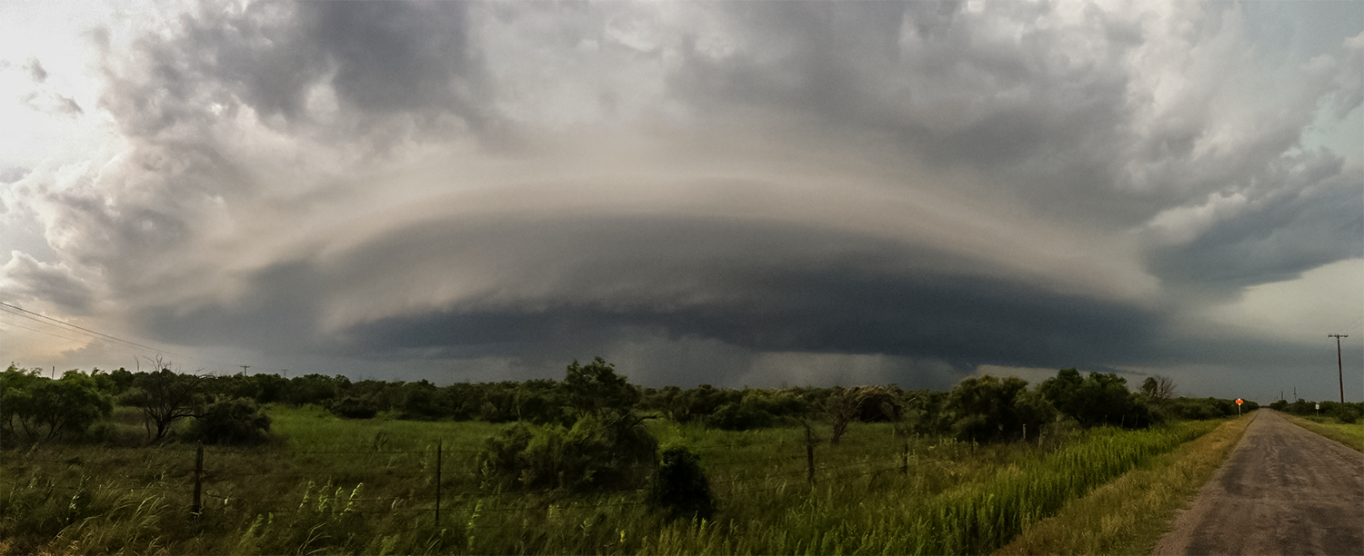
10 minutes later, we pull off the road to admire this astonishing sight....


WOWSA!  Seeing this made the entire trip totally worth it!!  The structure on this storm was simply incredible.  The striations of the mesocyclone were clearly visible - indicating that this storm was indeed rotating.  Looking to the right of the storm I noticed something that I hadn't seen before in person - an inflow band, also known as a beaver's tail.


This section of the storm is the boundary between the warmer air flowing into the storm (inflow) with the rain-cooled air (outflow) rushing out of the storm.

We continued to follow this beauty for the next 20 minutes but with it being so late in the day, the lack of light soon prevented my iPhone camera from doing any more good. We officially broke off the chase and headed back towards Wichita Falls to grab a late dinner.

The long drive home gave me plenty of time to reflect on the amazing sights I had seen that evening as well as come to the realization that the spring chase season was probably coming to an abrupt halt.  The long, hot days of summer were soon going to eclipse the exceptionally wet and active spring we had.  All in all, Spring 2015 was fantastic and I can't wait for more chases ahead.

-Andrew


Sunday, June 21, 2015

A Wall Cloud for Mother's Day (Part 3 of 4)

One usually doesn't associate Mother's Day with storm chasing (especially if you're married with kids), but 2015 has not been an ordinary year!  The Mother's Day weather outlook was unsettling to say the least.  The 8AM (1300Z) update from the SPC had placed parts of North Texas into the enhanced risk area for severe weather.


There was a fairly complex scenario unfolding throughout the day.  First, a large group of thunderstorms, known as an MCS, was surging eastward along the Red River - the border between Texas and Oklahoma.  This storm complex was creating an outflow boundary which was expected to interact with a cold front and dry line that was forecast to pass through the area later in the day.  Mix in strong wind shear - a change in wind direction with height - and very high humidity and you have all the ingredients for some crazy weather.  By 9:50 AM, the SPC had already issued Mesoscale Discussion #583 giving an 80% chance of a tornado watch being issued.


25 minutes later - at 10:15AM, Tornado Watch #155 was issued for a large part of Texas.  A previously issued watch encompassed eastern Oklahoma and western Arkansas.


By 11:30 AM (1630Z) the SPC upgraded an area of Central Texas to the moderate risk for severe weather.


We had made plans to all go out to Panera for a Mother's Day lunch and I had pretty much assumed that storm chasing would be a taboo subject and completely out of the question - no matter how good the setup was.  To taunt me even further the 3PM (2000Z) SPC update further expanded he moderate risk area to encompass a large area of North Texas - and our area was completely in the target area.


Other than going out for lunch, we stayed home and laid low.  By afternoon the kids were getting restless and I'm sure that my frequent glances at the radar and mentions of weather watches had absolutely NOTHING to do with what happened next, but it was my WIFE who suggested that we go storm chasing.  Despite assurances that this was her day and that it was almost getting too late in the day to chase, she insisted.  Now who am I to argue with such a request?  We packed the kids in the car (they like to go too!) and went to go pick up my dad - who is typically the designated navigator when we chase. 

Shortly after 4PM, we headed out.  Our targets were extremely limited and when I say limited, I mean there was only one - an exceedingly large severe thunderstorm west of Waco, TX.  My plan was to head south down I-35 and cut west on US-84 and head toward the storm.  The problem with this plan was that it was getting pretty late in the day and the target was pretty far.  Despite my best efforts to stay positive, I had pretty much come to the conclusion that we'd drive until dark and if we were lucky, we'd maybe see a cool shelf cloud or something.  At 4:23 PM, the target storm became tornado warned.  This certainly piqued my interest, but I was keeping hopes at bay.


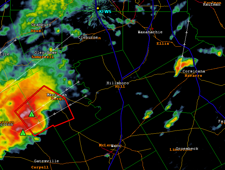
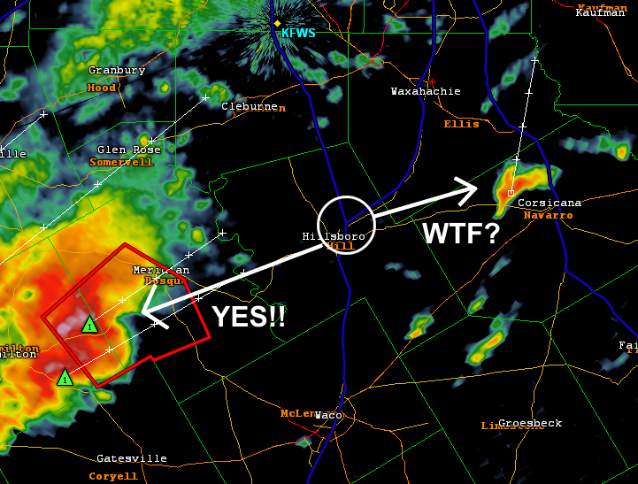
After looking over the radar, I did have some concerns about this storm.  For starters, it looked like an HP - or high precipitation - supercell.  This type of storm has a tendency to hide its tornadoes in a curtain of rain and makes them extremely dangerous to chase due to the low visibility.  To make matters worse, seemingly every storm chaser in the region was converging on this storm.  Not wanting to deal with these factors, I began panning around the radar to see what, if anything , we could target.  We were still north of Hillsboro, TX when something to our east caught my eye.  In the image below, do you see that storm to the west of Corsicana in Navarro County?  What about that one?  Is it growing/shrinking?  Did I see rotation on the radar?  All these questions came pouring into my head and I knew that we'd have to make a decision.  Was it smart to abandon our initial target and go after a long shot?  No pressure whatsoever!!!


Looking back, I think I made the decision I did out of an abundance of caution.  I'm not the most experienced chaser and I did have my wife, father, and kiddos in the car.  I really didn't want to approach a rain wrapped tornado and have all things go to hell.  Therefore, I made the decision to change the plan mid-way and after arriving in in Hillsboro, we made our way onto TX-22 and blasted east with a new target in mind.  All I was thinking was "I hope I made the right choice!!"

What I hadn't taken into consideration that although the new target storm was technically closer, it was also going to be moving away from us - which means that catching up to it was going to take some skill.  Any delay we might encounter would just make getting to the storm all the more difficult.  As we passed through the small towns along TX-22, the speed limited drastically lowered and I was getting more and more frustrated.  As an aside, I always turn out to be the biggest pessimist while chasing.  I think that's my way in dealing with a potential bust.  In other words, I mentally prepare myself for failing in the event that it happens.  What a horrible thing to do!  I really need to work on that for next year.  :)  Ok - lesson learned.

It seemed like an eternity, but we finally made it to Corsicana and, like I eluded to earlier, the storm was much further to our north.  We had a lot more catching up to do so we hopped on I-45 northbound.  Just north of the town of Rice, TX, we needed to take a more easterly direction to get in a better position so we had to exit the interstate.  We opted for FM-1182 which took us to FM-85.  We continued on that for a while, then took FM-2613 north.  Wait - talk about Déjà Vu!  The route we took since exiting the highway matched exactly that of a previous chase from 2014.  See that story here!  Being familiar with the area and road network boosted my confidence in my ability to catch up with the storm.  However, an even bigger confidence boost came from what we saw next.


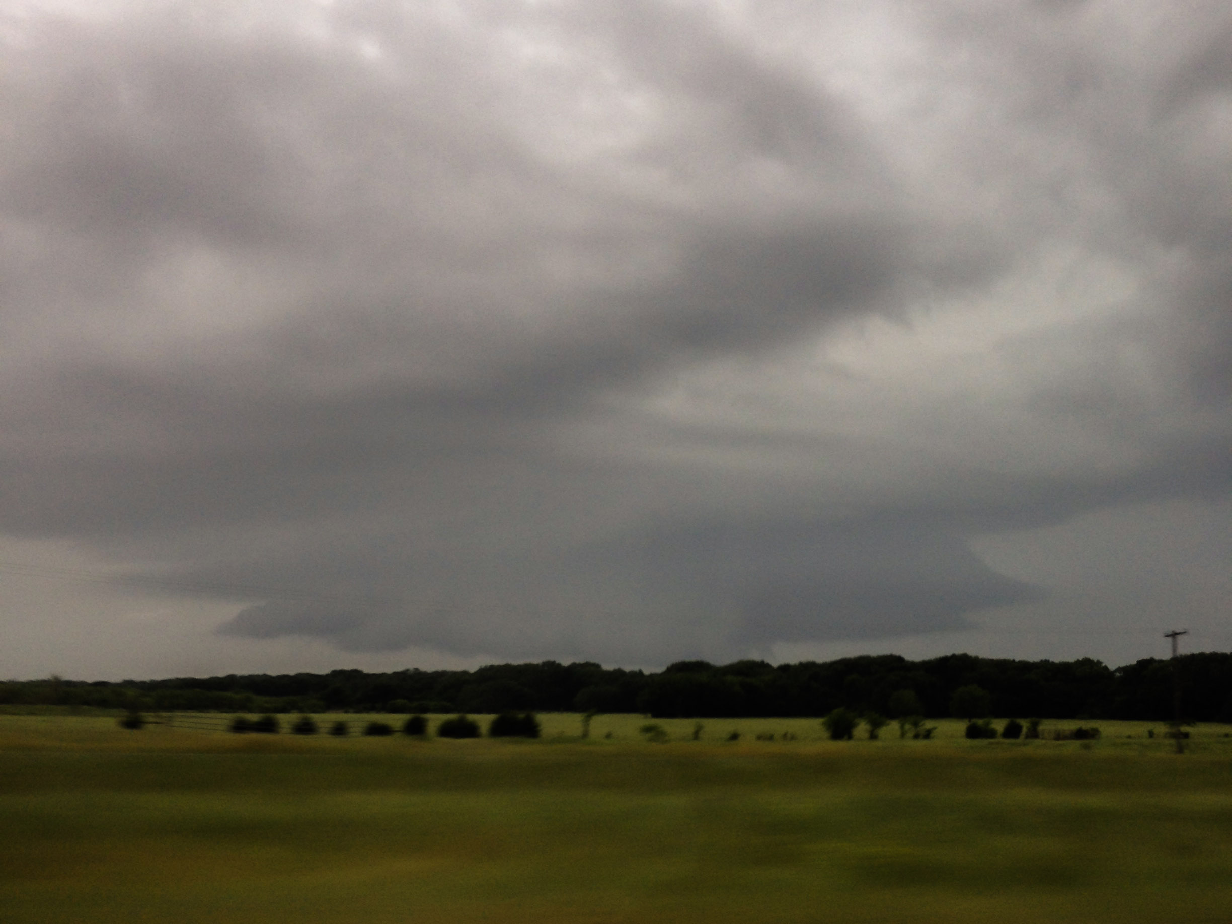
This may not look like a whole lot, but to a storm chaser, it's validation that you're heading in the right direction.  This shot is from northbound on FM-2613 and is looking the storm's backside.  The dark area of clouds just beneath the power lines the storm's updraft base.  Looking up further is the rest of the updraft core billowing high into the atmosphere. 

When you're close enough on a storm for visual contact, it next becomes all about positioning.  One technique is to get on the storm's right flank.  This is important for a few reasons.  First, it allows for the some of the most photogenic views and second, it's one of the safer places to be.  Knowing that we were on the storms south side (rear flank), we knew where we had to end up.  Upon reaching the town of Kemp, TX, something fantastic happened - the storm became tornado warned!  The actual warning was issued at 5:55PM - about 90 minutes after we made the decision to chase down this storm.  WHOA!  Our luck was suddenly paying off!  WOO HOO!

Here's a shot of storm on radar and our position relative to it just after the warning was issued.  We seemed to be in a really great position - having placed ourselves east of the storm with a north road option to intercept.  Things were now coming together nicely!!


With the chase officially in full force, we drove north on US-175 toward the town of Kaufman, TX keeping eyes on the storm the whole time.  10 minutes later we finally got close enough to see why a warning was issued.


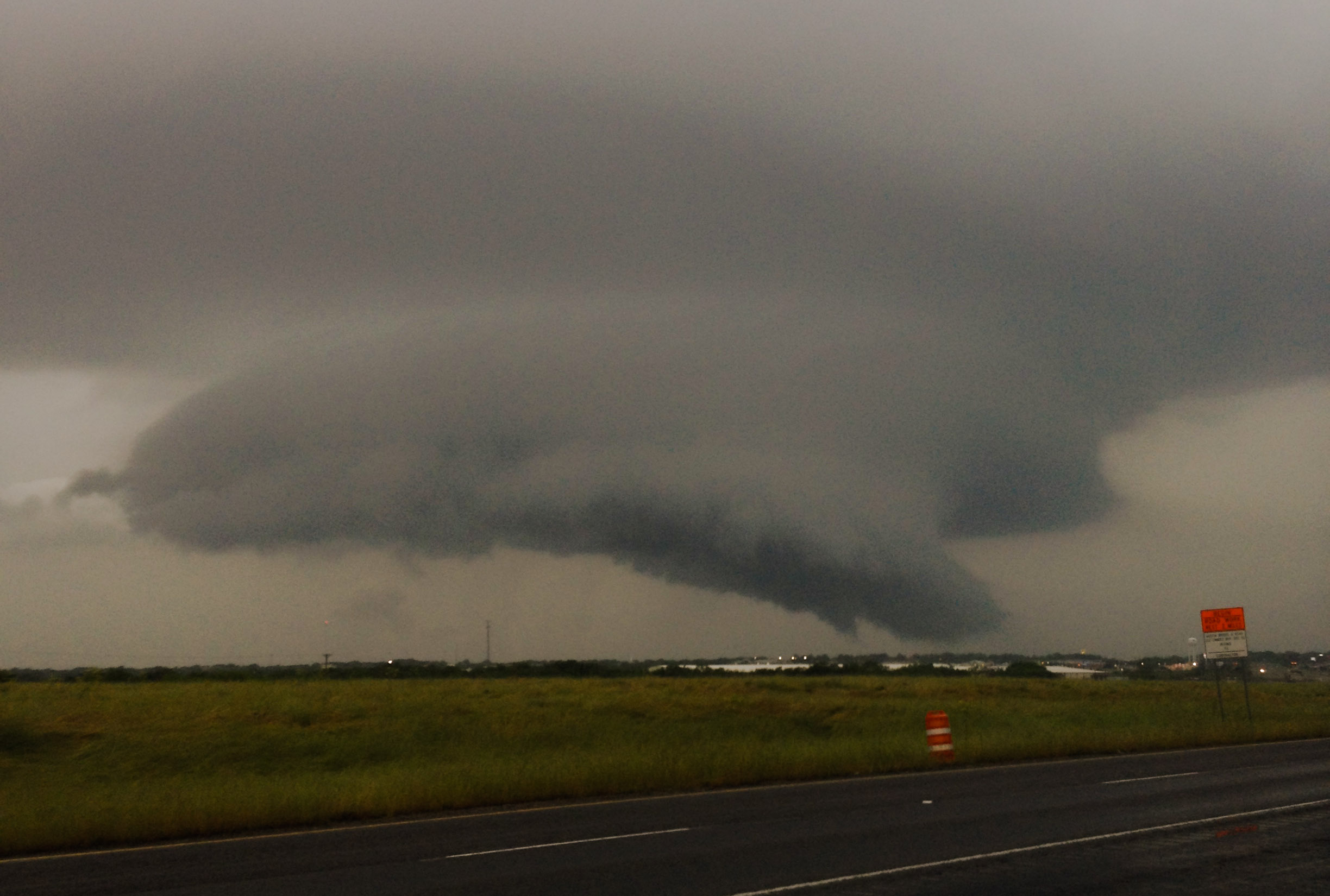
BOOYAH!  That my friends is a WALL CLOUD.  A wall cloud is the most intense portion of the storm's updraft base and is the area where a tornado will form if conditions are just right.

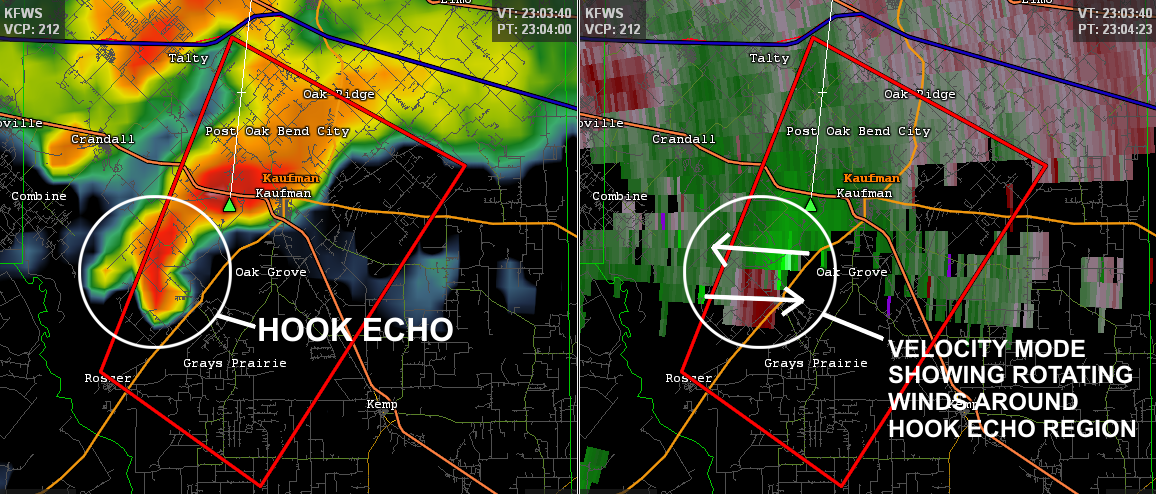
One of the cool things about reconstructing a chase like this is to go back and pour over all the data that you don't have access to in the heat of the moment.  I typically only chase with 2 pieces of technology: an iPhone and an iPad.  The iPhone is used mainly by me and gives me a quick view of the radar.  This helps me know where I am in relationship to the overall storm.  I can then relay this to the navigator - usually my dad - who can then tell me what the road options are.   The iPad has radar as well, but is used mainly for maps by the navigator.  After experimenting with this setup over the course of a few chases, we found that this method works pretty well.  Keeping the technology at a minimum, we're not buried in phone and computer screens while on the road and it forces us to actually look at the weather to make sense of it!  There are some disadvantages though.  The main radar program I use (the one on my notebook) gives a much more detailed view of storms.  As an example here is a radar view from the same time frame as the above photo.  This is showing the storm's reflectivity data (the amount of precipitation) as well as the velocity data (the wind speed/direction).  It clearly shows indicators that would justify the tornado warning being issued - the hook echo and the velocity signatures indicating rotation.  While this same data is available via the iPhone/iPad, it's hard to change views on the fly - especially when there is a limited cellular connection.

 
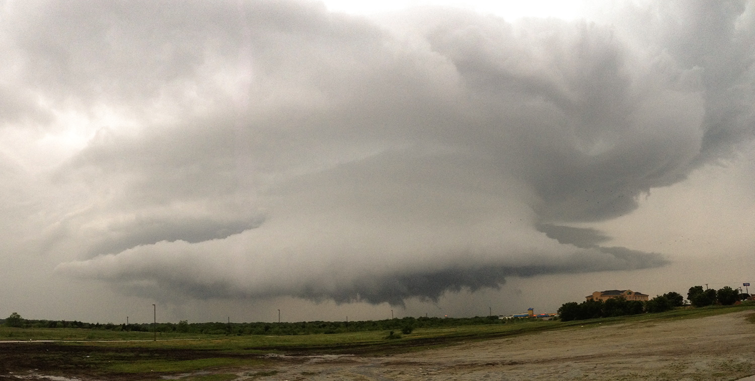
Another 10 minutes of heading north - we were just south of Kaufman, TX.  It was here that we saw one of the best sights I've seen to-date.  Here it is in all its glory.


Just LOOK at that beast of a wall cloud.  It looked like it was so low, it could almost scrape the ground.  Now remember: this is the part of the storm that could produce a tornado at any time.  So, while (as least to me) it's the most beautiful, it's also the most dangerous - unless you don't factor in any large hail that could be falling downrange as a result of such a large and powerful updraft.  :)

In order to take these pictures we had pulled off the road into a business parking lot.  Cars were slowing down along the main highway and we even had people stop to ask what was going on ahead.  I was a bit taken back by these questions and wanted to say something snarky, but I quickly relied on my spotter training - which the role is to WARN people - so I let them know that this was a tornado warned storm and to be extremely careful if they were heading up the road. 

We watched this beast slowly drift northward and when it was clear of US-175, we got back into the car and planned our next move.  We decided that following TX-34 out of Kaufman was going to be our best bet.  This route was projected to keep us east of the storm all while taking us northward.  At 6:30PM a new tornado warning was issued as an extension of the first.  The new warned area is shown below.

 
One of the more important, but difficult aspects to chasing is being able to provide ground truth to the National Weather Service.  Ground truth is vital because radar doesn't "see" all the way to the ground. It only sees what's going on higher up above the ground.  Furthermore, radar doesn't see clouds.  It can only detect precipitation.  As a result, meteorologists can infer things are taking place, but confirmation needs to come from people.  This is where the role of storm spotters/chasers really comes into play.   As an example, take a look at these photos.  The first is from about 6:30 PM - the same time the 2nd warning was issued.  The second, about 6 minutes later.


What are that white arrows pointing to?  Is it a tornado?  Is it just another part of the wall cloud?  Honestly, the question can't be answered with the information presented.  Sure - it may look like a tornado, but here's the textbook definition:  a rotating column of air that is extending down from a cloud base AND is in contact with the ground.  The problem here is that we can't see the ground and thus can't say for certain what is going on.  We can't tell if it's rotating either.  This is the real that challenge that storm spotters/chasers face - having to discern what really is from what we think we see.  If I had to say, I would classify it as a possible developing funnel cloud.
 
A few more minutes on the road and we found ourselves  at TX-34 and I-20, south of the town of Terrell, TX.  We found a place to park and got out to take another shot.  The storm was still very much larger than life.  By this time a number of vehicles had pulled into the same parking lot to take pictures as well. 
 
 
Due to a necessary potty break prompted by the kids, we lost a few minutes on the storm as it passed out of the area.  However we were all soon back in the car and on the road.  At 6:57 PM, the 3rd tornado warning for this storm was issued.
 
 
North of the city of Terrell, TX-34 veers on a more northeast course.  This allowed us to stay east of the storm, but the distance between us began to get bigger.  We would need to find a different road option soon or we may would have to break off the chase.  We still had some daylight left, but I knew it was possible that as the sun was continuing to go down, the lack of heating could be enough to begin weakening the storm.  I couldn't pinpoint the cause - but the entire structure of the storm was changing.  It could have been our increasing distance, but it also could have been because the storm was in the process of dying out.  With that said, around 7:04 PM we saw was appeared to be another funnel cloud develop.
 
 
We kept a very close eye on this, but over the course of the next few minutes, the funnel dissipated.  From this point on the storm was definitely in the process of dying.  The structure began to decay and lose its distinctive shape.  By the time we got to Quinlan, TX, we officially called off the chase.  At 7:30 PM the 3rd and final tornado warning associated with this storm was left to expire on its own.  We jumped onto I-30 for the long drive home.  I really would have liked to see a tornado that day, but looking at how many residential areas this storm passed over, I'm relieved that we didn't.  While some chasers may have called this a bad day, there were many things I considered to be wins.  Every chase is an opportunity for me to hone my skills.  Ditching a larger storm for something smaller one may have been a long shot, but it definitely paid off this time.
 
-Andrew

Friday, June 5, 2015

Too Close for Comfort - Twice! (Part 2 of 4)

Two days after our unplanned tornado shelter test, mother nature decided that it would be good to have another go at it.  The severe weather outlook for North Texas was pretty similar to what it had been on Friday, April 24 - in that for Sunday the 26th we were once again in the enhanced risk area. By the 11:30 AM update, however, the SPC had issued a upgraded parts of North Texas to a MODERATE RISK.  Areas included Dallas, Tarrant and Ellis Counties.

From the SPC:

EXPECT STORMS TO GROW UPSCALE INTO ONE OR MULTIPLE MCSS OVERNIGHT WITH THE RISK FOR POTENTIALLY MORE WIDESPREAD DAMAGING WINDS INCREASING ACROSS PORTIONS OF CNTRL INTO ERN TX.  LARGE HAIL AND A FEW TORNADOES WILL ALSO REMAIN A CONCERN. 


At 4:15 PM (2115Z), the first tornado warning was issued for Erath county - about 95 miles away as the crow flies.  Normally, this wouldn't be a big deal, but due to the directions the storms were heading that day, if the storms DID hold together, they'd be knocking on our door step in just a few hours. 
 
 
Just before 5 PM that evening, but we were put under a tornado watch.

 
Continuing its initial northeasterly track for about 2 hours, the leading storm which had prompted the first tornado warning started to fizzle out while another large supercell had formed in along the same track as the first.  Another tornado warning (#2) was issued at 6:18 PM (2318Z) for nearly the same spot.
 
 
 The new leading storm continued northeastward for a short while, but then began to take a right turn - an indication that the storm was strengthening.  Another tornado warning was issued at 6:39 PM (2339Z)
 
 
30 minutes into this new warning, the storm changes direction back northward and the 4th tornado warning was issued at 7:08 PM (0008Z).
 
 
Strangely enough, this leading cell soon began to die out and be replaced by a strengthening storm further to its southwest.  And just like its predecessors, a tornado warning was called for it at 8:15PM (0115Z).
 
 
After the hook portion of this storm moved out of Earth county and into Somervell county, it began to take and easterly (or right-moving) direction - possibly indicating that it was strengthening.  The 6th tornado warning of the evening was issued at 8:25 PM (0125Z) for the large storm complex to the northwest of this main supercell.  However, my main focus continued to be this monster. 
 
Over the next hour (roughly 8:40 PM to 9:40 PM), this huge storm made quite a bit of progress toward us. Tornado warning after tornado warning literally started to pave a way to our door.  No joke!  Here's an image of the outlines tornado warnings 7 though 11 - note the time stamps for each new warning. 
 
 
Notice how the last 3 warnings seem to get stacked right on top of each other?  That's because the storm pretty much became stationary around the Granbury area!  Reports of a mile-wide wedge tornado began to filter in on Twitter and broadcast media.  Luckily, these reports were grossly overestimated due to it being after dark.  Although radar velocity signatures were measuring a very wide rotation area, not all of that rotation was making its way to the ground.   Numerous tornadoes were confirmed, but all were EF-0.  Thank goodness!
 
The whole time this monster supercell was sitting in place, a separate complex of storms had been forming to the northwest. They grew much larger and appeared to move southeast -not east - like the leading storm until around 10:15 PM when what appeared to be 3 supercell structures were nearly in a due east-west line.  
 
 
Another 2 hours pass as I watch these storms begin to congeal into the biggest mass of colors I had seen on radar in quite some time.  Then, at 12:12 AM (a full 8 hours after the initial warning was called 95 miles away) a tornado warning was issued for parts of our city.  Our house wasn't directly in the warned area, but due to it being so late at night, we decided it would be safer to head for the shelter.  Due to the erratic motions these storms had performed all night we surmised that anything could happen - and we wanted to be ready.
 
12:20 AM - Safely with the family in the bunker, I catch my first glimpse on the radar and finally make sense of what I'm seeing - a distinct pattern known as an MCV (Mesoscale Convective Vortex).  An MCV is a low pressure center within a larger MCS (Mesoscale Convective System).  An MCV pulls winds into a counter-clockwise (cyclonic) rotating pattern.  The once individual supercells had merged and mutated ending up with the northern tip of the storm taking on a distinct comma shape.  This comma shape was set directly over my house! 
 
 
For about the next hour the MCV slowly rotated counterclockwise as it crawled off to our east - dumping copious amounts of rain during the process.  When the tornado warning for our city was let to expire, we decided to leave the shelter.  3" of standing water in the yard made the dash back into the house all the more exciting.  By 1:30 AM the storm complex had pretty much moved out of the county and with work looming just a few hours in the future - it was time to go to bed.
 
Trying to summarize 13 hours of weather is meaningless unless you have the whole picture.  To that end, I created the following animation (281 frames) which spans the whole duration of time I just described above.  (Watch on YouTube for a larger experience)


Thankfully on this day (and night) we were never directly under a tornado warning or threatened with any major storm.  But after parsing through all of the day's events to write this article, I'm still in awe of the power and complexity of mother nature - which is one reason why I love studying the weather.
 
-Andrew


Sunday, May 31, 2015

Too Close for Comfort - Twice! (Part 1 of 4)

Spring 2015 will certainly be a memorable storm season for a number of reasons. As I begin to write this article on the evening of May 30, 2015, North Texas has already seen about 85% of the rain that we would normally get throughout the year! Our normal yearly rainfall is about 36.1" and we have received 30.74" as of May 29. In fact, this is the first time since 2012 that all of North Texas is completely out of the "Severe Drought" category. These stunning facts hit both sides of the good news/bad news spectrum. Obviously the good news is that much of this great state is no longer under drought conditions. The rain for which we have prayed earnestly has shown up - nearly all at the same time. The bad news is that this has created catastrophic flooding throughout most of the state. The next few days is forecast to be rain free - which should hopefully give the swollen rivers and streams time to calm down a bit.

Apart from the record rainfall, we have seen a very high number of tornadoes as well! As of May 28, the Fort Worth CWA (County Warning Area) has had 57 confirmed tornadoes. A map showing the CWA as well as the breakdown in tornado strength is shown below (Image is courtesy of the Fort Worth National Weather Service office). The majority of these tornadoes were determined to be EF-0. People think that the EF (Enhanced Fujita) scale of rating tornadoes is based on wind speed, but the scale is actually based on the damage done by a tornado. The idea is that the higher the damage, the greater the likelihood of higher wind speeds.


The 4/24 listing from the above graphic is pretty significant for me. This was the first tornado for which we officially got to use our tornado shelter. You see, we moved to North Texas in 2006 and moved into our current house in 2007. Coming from Michigan, we always had friends and family inquire as to why we wanted to live in tornado alley. At the time I really didn't have an answer other than the fact that the economy down here was much better than up north. However, now that I chase storms for a hobby, the answer is blatantly clear!! Be that as it may, we were always cognizant of the fact that we did live in a tornado prone area. After going back and forth for a number of years and having a few close calls, we finally took action and in 2014 decided to pull the trigger and install an in-ground tornado shelter. Here's a picture of the "bunker" shortly after the install.


This behemoth weights in at just under 30,000 lbs., and is comprised of 5 1/2" thick steel reinforced concrete. It's supposedly F5 rated and I truly hope that I never have to test that out personally. 

Fast forward just over a year from the install date - to April 24, 2015:

The setup on this day was actually quite complicated. Storms that occurred the previous night were allowing for some uncertainty in the forecast. Still, much of north and central Texas were placed in the SPC's Enhanced Risk for severe weather.


The consistent theme throughout the day was the prediction that isolated supercells would form west of the DFW Metroplex and have the ability to "... grow upscale into multiple line segments/bows. Thus...large hail and damaging winds can be expected...along with tornadoes where cellular convective mode can be maintained..." (text lifted from the 4/24 SPC convective outlook page)

At 11:12 AM, the SPC put out Mesoscale Discussion #433 stating that there was an 80% chance that a tornado watch would soon be issued.


And sure enough at 2:10 PM, Tornado Watch #100 was issued for a large portion of north and central Texas.


This happened to be a Friday, so I left work early knowing that we may be in for some potentially crazy weather. After arriving home and trying to have a normal dinner time with the wife and kids, the first warnings of the area started to be issued. This image was from about 5:40 PM and shows the initial warnings near our area.

 
These warnings were 2 or 3 counties to our west, but they were tracking eastward very rapidly. The image above shows a local storm report (LSR) of a wind gust measuring 75 MPH along with 2" radar-indicated hail. These storms were nothing to mess with! Shortly after the complex moved into the DFW Metroplex, a tornado warning was issued for Tarrant County - which included the southern portion of the city of Fort Worth. By this time, the storms had done just what the SPC had predicted earlier - discrete cells had formed into a fast-moving line of storms.

Then, at 6:43 PM CDT, it happened - a tornado warning was issued for our area. We gathered the kiddos and let them know that we would have to go into the shelter - assuring them that this was safest place in the entire neighborhood! We gathered our stuff and headed into the bunker. It was very hot and stuffy in there and in the midst of trying to calm scared kids and listen to the weather radio I didn't realize that we had lost cell service - and in turn - lost radar visibility. Only after the tornado warning was cancelled and we were able to regroup inside our house did I find how crazy things looked.

 The following image, from around 6:50 PM, shows a split view of radar reflectivity (on left) and velocity (on right). The reflectivity image depicts areas of precipitation - with reds/oranges/pinks being the highest values. The velocity image depicts winds moving towards (green) or away (red) from the radar. The red outlined area is the tornado warning (a severe thunderstorm warning had already been issued) and my house is depicted by the red plus sign just north of the city of Waxahachie, in Ellis County. What's notable in this image is that a small inflow notch had formed on the leading edge of the storm. An inflow notch is an area that due to the mechanics of interacting winds, allows for circulation to take place. This notch was designated with a TVS (tornadic vortex signature) icon. While these icons are nothing more than algorithms generated by the radar and usually don't denote an actual tornado, it does highlight areas of enhanced inbound/outbound velocity. In this case, the TVS icon was right over the inflow notch and thus was the area of concern. If you look at the velocity portion in the area of the TVS, you can almost visualize a rotating section of the storm. The reds are moving left to right and the greens are moving right to left in a counter-clockwise (cyclonic) motion. (click the image for a larger view)


Over the next 2 frames of radar, the area of circulation seems to be heading in a quasi-northeast direction. Then something very interesting happens - the circulation changes direction and begins to head southeast - right towards our house! This change of motion does happen in discrete supercells as well. As they begin to intensify in overall strength, the storm changes its mean motion and begins to turn right - hence the term right-moving storm. With this line of storms too, that seemed to be what happened too. These next images show two velocity radar images - one at 6:58 PM and one at 7:00 PM. The brighter reds (the higher outbound winds) can clearly be seen moving to the southeast.
 
 
It is important to note that although a tornado warning was in effect, this was for radar-indicated rotation only. This means that although a tornado was not visually confirmed, the people at the National Weather Service felt that the radar showed enough persistent rotation to warrant issuing the warning.. Visual confirmation or not, any tornado warning is cause enough to seek shelter - which is exactly what we were doing at the time.
This image shows the circulation's closest approach to the house - a very close call indeed!


Finally, when the storms had passed and the outdoor sirens were turned off we all headed back inside. After settling everyone down I took my father, who had been with us throughout this whole event, around the neighborhood to check and see if there was any damage. Luckily the only thing we found was an overturned porta-john in the section of our neighborhood that is still under construction.


The setting sun made for an extremely high rainbow and the storms still racing to our east set the scene for this beautiful juxtaposition.


The next day, the NWS sent out survey crews and did confirm a brief EF-0 tornado south-southeast of Midlothian. It seems that the tornado spun up west of us but had dissipated and became a part of the larger straight-line winds before reaching us. Admittedly I was a bit nervous when all of this was going on, I did have good piece of mind knowing that we had our shelter in place. Here was the official release from the NWS:

ELLIS COUNTY TORNADO

RATING: EF-0
ESTIMATED PEAK WIND: 80 MPH
PATH LENGTH /STATUTE/: 0.87 MILES
PATH WIDTH /MAXIMUM/: 60 YARDS
FATALITIES: 0
INJURIES: 0

START DATE: APR 24 2015
START TIME: 652 PM CDT
START LOCATION: 3SSE MIDLOTHIAN
START LAT/LON: 32.45/-96.96

END DATE: APR 24 2015
END TIME: 654 PM CDT
END LOCATION: 3.8SSE MIDLOTHIAN
END LAT/LON: 32.45/-96.95

SURVEY_SUMMARY: THE EF-0 TORNADO WAS A SMALL PART OF A MUCH LARGER SWATH
OF DAMAGING WINDS TO THE SOUTH OF THE CITY OF MIDLOTHIAN.

EF SCALE: THE ENHANCED FUJITA SCALE CLASSIFIES
TORNADOES INTO THE FOLLOWING CATEGORIES.

EF0...WEAK......65 TO 85 MPH
EF1...WEAK......86 TO 110 MPH
EF2...STRONG....111 TO 135 MPH
EF3...STRONG....136 TO 165 MPH
EF4...VIOLENT...166 TO 200 MPH
EF5...VIOLENT...>200 MPH*
 
The weather setup for the next few days was much of the same - but little did we know at the time that we'd have to use the shelter again so soon!

-Andrew