Showing posts with label north texas. Show all posts

Monday, February 9, 2015

Can't We Get Rid of This Persistently Nice Weather?

Am I going crazy?  Why would anyone want to get rid of such nice weather?  Surely I must be joking, right?  Well, yes and no.  While I do enjoy nice sunny days, I very much long this time of year for the excitement of the spring storm season.  The clean, dry air of high pressure days, while pretty, just doesn't do it for someone who always is looking at the clouds.  A quick view of our extended forecast for North Texas puts daytime highs in the 60s and 70s - with only a few days mixed in with very low precipitation chances.  Boo!  (Can you feel the sarcasm dripping from this post??)

As it turns out, I actually can blame this weather on something:  a Rex Block

Who is Rex Block?  Well, a Rex Block isn't a who, but a what.  This is a meteorological term for a specific type of blocking pattern.  Blocking patterns are relatively stationary weather patterns that block other systems from coming through.  The Rex Block is a special type of blocking pattern in which an upper level center of low pressure is situated directly southward of an upper level high pressure center.  It was named after Dr. Daniel F. Rex who named this pattern in 1950.  Here is an idealized diagram:

Winds from the west encounter the high pressure area and begin to flow clockwise around it, then start to flow counter-clockwise around the low pressure area.  In other words, the winds blow in a backwards S pattern from north to south.  As there little west-east flow, this pattern can persist for days.

Here's what our current weather pattern looks like.  This image is taken from the NAM weather model.  It shows the 500mb weather patterns (winds at around 18,000 ft. above the ground).

 
There's a few features that I need to point out so that all of this makes some sense.  I've added a large, blue H over northern Mexico.  This (as I'm sure you've seen countless times on other weather maps) is an area of high pressure.  High pressure generally gives clear skies and dry air - exactly what we have today. Also, take a look at the solid black lines.  See how they make patterns that look like a large right-side up and upside down U?  Now look at how Texas is west of one of these U-shaped features.  Generally speaking, the western side of the U tends to have sinking air (i.e. high pressure) and fair skies, while the eastern side of these U shapes generally have rising air (low pressure) and cloudy skies.  
 
The large, red L is of course a low pressure area - responsible for clouds and rain - exactly what is happening in Washington and Oregon today.
 
As the NAM continues over its 84-hour forecast period, it shows the low swooping down from the Pacific Northwest, but then starts to retrograde (or move westward) and finally positions itself on the north end of the Baja Peninsula, directly southward of another high pressure ridge.  This pattern now forms the classic Rex Block.  Here's the 84-hour forecast NAM view.
 
 
You'll notice how Texas continues to be generally westward of one of those U shapes.  Again, this region generally has sinking air and fair skies.  When you add the effects of the Rex Block, it's going to ensure that we have clear sailing for a long time to come.  The GFS weather model also shows a Rex Block for the same time period (roughly 84-hours out).  However, because the GFS forecasts out to 240 hours, it also shows that we could be in for a nice change (and by that I mean RAIN) by early next week. 
 
Until then - enjoy the weather!


Sunday, August 17, 2014

The Dangers of Downbursts from Pulse Severe Thunderstorms

On Saturday, August 16, 2014, the Storm Prediction Center put all of North Texas into it's lowest probability category for severe weather. 


Our area didn't even make it into a SEE TEXT region, yet with our moderately unstable air and weak wind shear environment, conditions were favorable for pulse thunderstorms which were capable of producing a phenomenon called DOWNBURSTS.

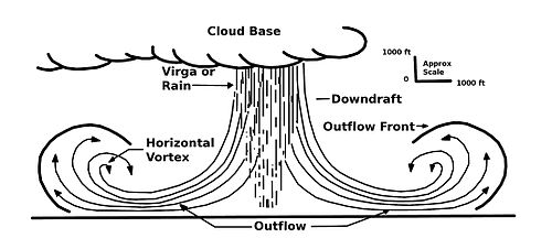
A pulse thunderstorm is a single-cell thunderstorm forms and dissipates relatively quickly and typically doesn't yield any severe weather.  However, some pulse storms grow fast enough and drop enough rain to produce a downburst.  A downburst occurs when rain-cooled air falling out of a thunderstorm hits the ground and begins to spread out in all directions.  This expansion of winds (called outflow winds) can sometimes reach 100 MPH and cause quite a bit of damage!  The easiest way to visualize this is to imagine pouring water out of a glass and onto the ground.  As the water slams into the ground, it immediately fans out in all directions, pushing air in front of it.  Is this forward motion that can drive winds as far as 50 miles away from the original storm.  Here is a good visual representation, shown in cross-section. (h/t Wikipedia)


There are actually 2 varieties of downbursts - wet and dry.  A wet downburst happens when rain falling out of the thunderstorm reaches the ground.  A dry downburst happens when rain falling from a storm evaporates before hitting the ground.  In either case, it's the outward-spreading winds from this cooler, sinking air that is responsible for causing damage.  Downbursts smaller than 2.5 miles in diameter are called micro downbursts or microbursts.  Downbursts greater than 2.5 miles in diameter are called macro downbursts or macrobursts.

Let's examine a real-world example of downbursts.  This example begins northwest of Fort Worth, TX.  At 3:02 PM, the National Weather Service issued a severe thunderstorm warning for northwest Tarrant and northeast Parker county.

 
Although the radar returns look unimpressive, there were some interesting things that were about to happen.  One of the dangers with downbursts and the storms associated with them is the speed in which they form, drop their rain-cooled air, and eventually collapse.  The following 5 snapshots of radar reflectivity and radar velocity start at 3:12 PM (about 10 minutes after the initial warning was issued) and ends at 3:31 PM - a span of only 19 minutes!! 
 
TIME 3:12 PM
The first thunderstorm core is in the process of growing. 


TIME 3:17 PM
The first thunderstorm core is still in the process of growing, while a new core is forming to the northwest.


TIME 3:22 PM
The first thunderstorm core has matured fully and has begun to produce a downburst (visible on the right side of the image).  The velocity view clearly shows that winds directly underneath the thunderstorm are hitting the ground and are spreading out.  The red colors indicate winds that are blowing away from the radar, while the green colors show winds blowing toward the radar.  The second thunderstorm core continues to grow.


TIME 3:27 PM
The first thunderstorm core is now in the dissipating (or dying) stage.  Reflectivity values (intensity of rain) has dramatically dropped off.  The outflow winds from the original downburst have spread further and further apart.  The second thunderstorm core continues to build up.


TIME 3:31 PM
The first thunderstorm core is now simply an area of heavy rain, while the second thunderstorm core has finally reached its mature stage.  It too has begin to form a downburst beneath itself as indicated by the diverging velocity signatures.
 
 
Let me reiterate that these 2 thunderstorm cores formed, matured, created downbursts, and began to dissipate in about 30 minutes total.  When damage can occur from these storms in such a small amount of time, it's crucial to be aware of the weather in your area.  Boaters and others enjoying open waters are likelier to get caught off guard as the there is little in the way to shield outflow winds that blow across these bodies of water.  Luckily, the downbursts in northwest Tarrant county did not produce any damage to my knowledge.  However, numerous power outages along with downed power lines and trees were reported just north of the downtown Dallas area due so similar conditions.
 
-Andrew